Local Smithers historian, the late Harry Kusselbrink, wrote a book called “Crossing the Bulkley,” in which he explained when the train finally reached Smithers, it presented a new problem for the Bulkley Valley. The need to unite the two sides of the valley across the Bulkley River.
Prior to the bridge’s completion in 1914, the two sides of the valley were entirely cut off from each other, except by boat. The bridge created a physical link between the two sides and saw increased economic, social, and cultural activity between them.
According to Kusselbrink, valley residents had waited for years to be connected to the rest of Canada, and the Grand Trunk Pacific Railway (GTP) provided that link.
What the residents had not anticipated was due to where the train station was located (along Railway Ave., where it remains today), the people on the east side of the valley did not have access. This left members of surrounding communities and villages cut off from badly needed goods, materials and supplies the train would bring. It also denied them the ability to send goods to sell, and the ability to travel out of town.
“The coming of the railroad was a singular event that had an impact on the valley and its development unmatched ever since,” Kusselbrink explained.
“It meant many positive changes for valley residents but, of course, some adjustments also had to be made. One of those adjustments was a shift of the main transportation corridor through the valley from the east side to the west side of the valley.
“Previously, the only access into the valley was by road on the east side of the valley. That road, for the most part, followed the right-of-way of the Collins Overland Telegraph Line that came through the valley in 1866. With the passage of time, it became a wagon road and, later, a regular road.”
It was called many names, the “Telegraph Trail,” the “Hazelton-to-Aldermere Wagon Road,” and finally in the 1920s it was officially designated as the Telkwa High Road, the name we know it as today.
The railroad, on the other hand was located on the west side of the valley.
“If the farmers, ranchers and miners were to truly benefit from the coming of the railway, much better access to it and to Smithers was essential. The solution was obvious — a bridge would have to be built.”
The new bridge was located at the foot of Main Street, and was a four-span Howe Truss single-lane bridge, with each span being 30 metres (100 feet) long. With the approach on either side, the total length of the bridge 156 metres or 512 feet.
It connected Main Street to what is known today as Ebenezer Flats.
The location, however, presented two problems. There were steep hills on either side of the bridge to be negotiated and on the Telkwa side of the bridge (east side) there was a 90 degree turn to get onto the bridge.
“That sharp turn always caused headaches, especially for heavier traffic, and even more so during the winter months,” Kusselbrink said in the book.
Mother Nature provided the biggest challenge, however, and ended up being the destroyer of the original bridge. A replacement bridge was built on the same site in 1943. Ice jams, flooding and debris build-up were responsible for the original bridge washing out twice, so when the replacement bridge was constructed, it took into account the flooding and ice problems, and was built wider and three and a half feet higher than the old bridge.
Even though the construction had taken into account flooding and all the other natural forces, protection of the bridge was a continuing problem. Dynamite was used to break up ice jams for many years, but even using drastic measures did not prevent sections of the bridge from washing out.
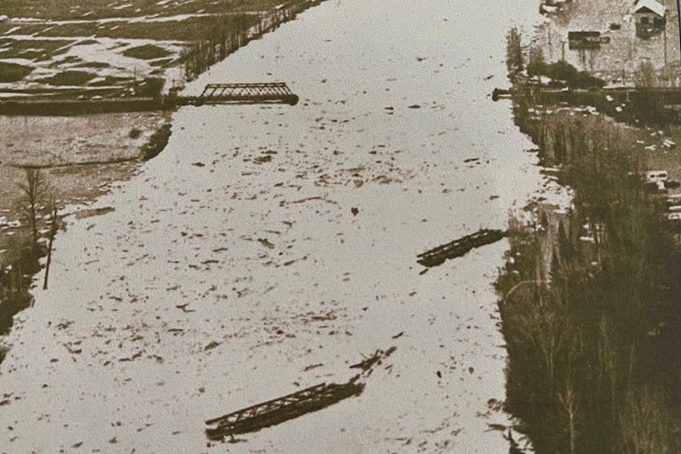
Then on Good Friday, April 8, 1966, the new Bulkley Bridge lost two of its three spans.
“The two spans on the Smithers side of the bridge were totally demolished by a massive ice jam that overwhelmed the bridge,” Kusselbrink said.
The jam swept the spans downstream as far as Riverside Park. Remnants of the old bridge are still visible at the bend in the river bordering the park.
“As a result of the loss of the bridge, the Telkwa High Road became the designated by-pass route to Moricetown for traffic to and from Smithers. That was a detour of approximately 72 kms,” Kusselbrink explained.
This diversion too, became troublesome, due to high traffic, and mud and eventually became of limited use.
“Meantime, the Department of Highways engaged the services of Okanagan Helicopters to ferry freight and passengers between their heliport on the Telkwa side of the river to the Smithers side,” Kruisselbrink continued.
Kusselbrink recalled the helicopter rides being a rather unique way to go to work and was enjoyed by all who took the opportunity to make the quick journey across the river.
The Department of Highways finally completed a series of Bailey bridges — portable, pre-fabricated, truss bridges developed by the British for use during the second world war — to replace the spans of the bridge that had washed downriver, but it was a temporary means to cross the river until a completely new bridge, at a different location could be built.
In 1966, the money was finally allocated for the construction of a brand-new concrete and steel bridge, which would also require the realignment of Highway 16. At the time the cost of the new bridge, was just over $1 million.
The new bridge, and realigned highway was officially opened on Aug. 22, 1969, and the remainders of the old bridge at the foot of Main Street were removed and demolished.
The old site of the bridges at the base of Main Street can still be seen and a viewer can vaguely make out the 90-degree bend and trail up the hill on the Telkwa side of the river.
Today, the Bulkey Bridge stands as a testament to the spirit of the original builders, a reminder of the bridges that were built to foster connections between people, and the communities they connect.
deb.meissner@interior-news.com
Like us on Facebook and follow us on Twitter