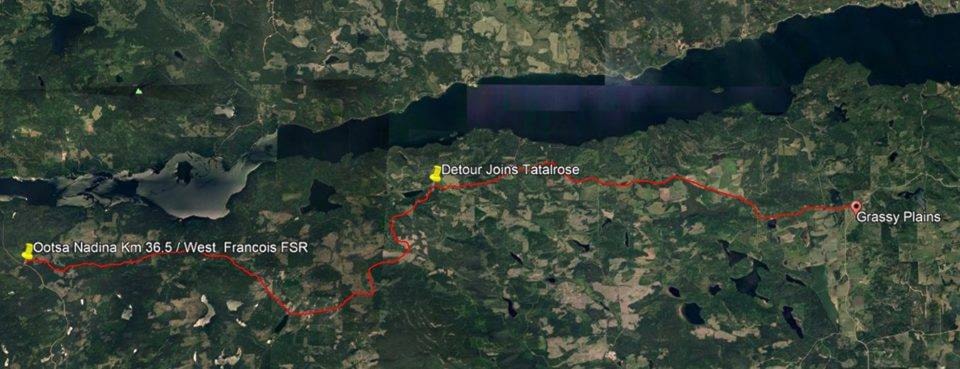
Maintenance workers have created a detour around a stretch of Ootsa Nadina Road destroyed by floodwaters, one of several areas in the Lakes District affected by the rapid spring melt.
The detour links a logging road to Tatalrose Road, which leads to Keefes Landing. This connects motorists to the ferry terminal that serves as the primary transport link to the Southside area.
Snow had to be cleared from the West Francois Forest Service Road to create the detour, which was open by May 3, according to Mike Philip, quality assurance and planning manager at Lakes District Maintenance (LDM), the company responsible for highway services in the region.
Situation isolating
Nancy Plesko, who lives near the site of the wash-out at the 12 km mark on Ootsa Nadina Road, said the situation has left her concerned about access to emergency services and made it difficult to get to work. “It’s fairly isolating,” she said.
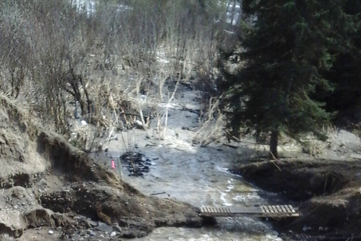
She said that people from the community have installed a footbridge across the stream that knocked out the road, with ropes to help them climb and descend the banks of the ravine. Some residents have cars on either side of the gulch, allowing them to avoid using the detour, she said.
Plesko also said that children — with adults — have been using the bridge to get to the school bus.
Philip declined to comment about the safety of the footbridge, saying that he hadn’t seen it and that it was likely on private land.
While her husband has been using the footbridge to cross the ravine and drive to work at a Southside garage, Plesko said that she has turned down shifts at Grassy Plains School, where she works as a substitute teacher and in other roles. Navigating the alternate route in the family’s second car would take too long to respond in time to on-call shifts, she said.
She said she was concerned about how quickly first responders would be able to get to the area, adding that there are 15 households on the far side of the gully, including elderly people.
“My concern is just emergency services,” Plesko said. She later told the Lakes District News that she and her husband drove an elderly neighbour around Lake Francois when he needed to go to the hospital early on the morning of May 5. “I did not trust the alternate route,” she said.
Kathy Hoesing, another resident from the area, said that she tried to drive around Francois Lake on May 4, only to find Colleymount Road closed for repairs.
Hoesing ended up turning around and taking the detour route to the ferry. She said that conditions on the forest road were decent in a truck — though perhaps not in a car — but that there was water on some parts of the road.
She said she wished there’d been a sign indicating the road closure on Colleymount, since it resulted in several hours of delay.
Social media updates
Updates about flooding have appeared on LDM’s Facebook page, but the company’s website didn’t appear to contain any mention of the wash-out or detour by May 7, with the latest update in the news feed being from April 2012. Philip said this was due to a technical problem that he would look into.
The company has also been issuing information related to flooding through local radio and Twitter, said Philip. He added that updates are also sent by email to first responders including the RCMP, ambulance and fire services, and that the company stays in close contact with the provincial ministry of transportation.
He encouraged residents who see flooding or have questions to call the company’s toll-free number, adding that calls from residents will be returned if they leave a message.
“We just ask that people call in, and we’ll address their concerns,” he said.
Rebuild begins
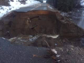
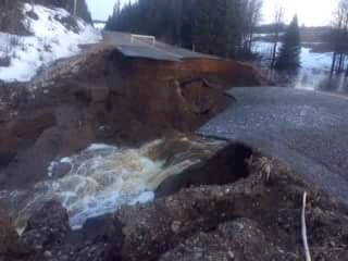
As for the washed-out section of Ootsa Nadina Road, work has begun on rebuilding the massive hole created by floodwaters. The chasm measured 24 m across and 7.5 m deep, according to Philip.
On May 3, he said the company was aiming to have one-lane traffic open within about two weeks, after workers prepare the site for the installation of culverts that are currently being built to size.
Philip said the edges of the road opening onto the breach will have to be cut back to create a slope, allowing for heavy machinery to descend into the gap.
“We have to ramp it back quite a ways to get our equipment down in there,” he said. The ramp will also make the route passable for one-lane traffic, Philip added.
The Ministry of Transportation and Infrastructure noted the detour on its Twitter page for the Bulkley Valley, Lakes and Stikine area, adding that motorists should follow “detour signage and drive with care.”
In a May 1 statement, the ministry advised motorists to use Colleymount Road as an alternate route following the wash-out at Ootsa Nadina. No injuries or damage to vehicles were reported as a result of the wash-out, according to the statement.
Photos from the scene showed a torrent of water rushing through a chasm strewn with rubble. The road washed away after a spike in temperatures resulted in accelerated snowmelt.
The Lakes District News witnessed flooding on several sections of Ootsa Nadina Road on April 28, as culverts appeared unable to handle rapidly melting snow.
Wash-outs on several arteries
Flooding washed out part of Colleymount Road, wrecking the pipes at the 24 km mark and causing delays, but repairs were complete by May 4, Philip said.
The company had also completed repairs on a section of Highway 16 east of Burns Lake where part of the shoulder had collapsed.
Flooding produced wash-outs leading to single-lane traffic on three section of East Tchesinkut Lake Road, but two-lane traffic had resumed on that route by May 3.
Two-lane traffic had also been re-established on to East Ootsa Lake Road following a wash-out there, Philip said.
The company was monitoring the situation as temperatures climbed again on the weekend of May 5-6, including on roads that have seen flooding but no major damage. “We’re going to be doing day and night monitoring of those,” he said.
Heat hits snowpack
By the beginning of April, the snow-water equivalent — a common measure of snowpack levels — stood at 204 mm in Burns Lake, compared to an average of 119 mm between 1981 and 2010. That means the snowpack was 171 per cent the historical norm.
That high snowpack combined with a sudden spike in temperatures to create flooding conditions in the Lakes District.