High snow pack has raised the risk of spring flooding to above normal in the Skeena and Nass snow basins, but whether major floods occur depends largely on what weather the area gets in May and June.
Those findings come from a snow survey report published March 7 by the BC River Forecast Centre. The report relies on snow level data collected up to March 1, the date by which about 80 per cent of the B.C. snowpack has finished building up.
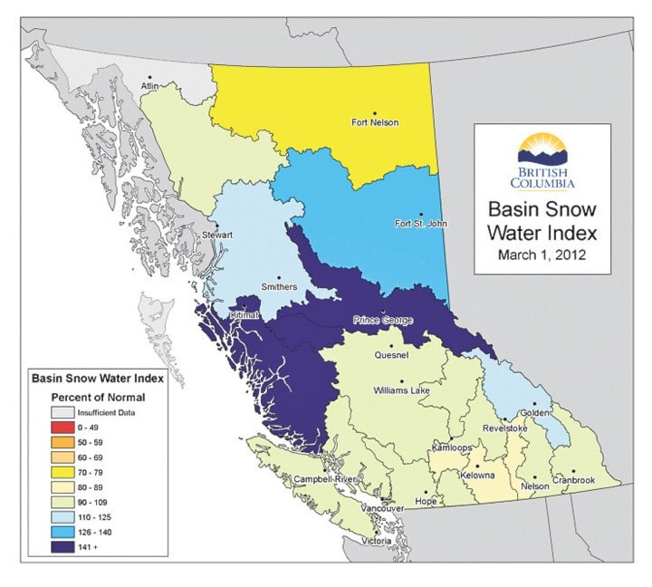
Northern B.C.’s snow pack levels are unusually high this year. Overall, the snow basin index for the Skeena-Nass survey area is 125 per cent above normal.
Snow courses on Hudson Bay Mountain, Mount Cronin and at McKendrick Creek were 134, 120, and 126 per cent above normal as of March 1.
Levels for those three courses are still well below record highs set over the last 40 years.
Across the province, snow pack levels are highest in the Upper Fraser and Nechako snow basins, which were measured at 144 and 158 per cent above normal.
Those B.C. snow basins with the highest snow pack levels, and some southern Interior and Okanagan basins that had lower-than-normal levels both normalized somewhat thanks to warmer and drier weather in February, the report said.
Looking ahead, the report said a continuing breakdown of La Nina weather patterns should lead to more typical spring weather, although that also means existing high snowpacks likely to be maintained through to the May and June snowmelt.
For the full report, visit www.bcrfc.env.gov.bc.ca.